Solar Geometry
This lesson was developed by architectural engineer Tony Esposito, Ph.D., during his graduate studies at Pennsylvania State University and made available to eGFI Teachers. The sun’s position is one of the factors that lighting engineers like Tony take into account when designing buildings, including solar homes.
Note: This lesson applies verbatim only to the northern hemisphere, but inferences can be made about the southern hemisphere.
For other eclipse-related math activities, see NASA’s Citizen Explorer’s site, which includes downloadable activities such as calculating the moon’s distance and speed of its shadow crossing Earth.
Summary
Middle school students learn about the Earth’s geometrical relation to the sun by calculating where the sun will be in the sky for any date or time given a particular location on Earth, such as their school.
Grade Level: 8th grade (complexity and computational requirements can be scaled down for lower grades)
Time: 3 periods of 50 minutes
Learning Outcomes:
After this lesson, students will understand:
- The geometric relationship between Earth and the sun
- Earth’s rotation
- How Earth’s axial tilt affects the Earth
- How time is quantified on Earth
- How position (location) is quantified on Earth
- How to quantitatively predict the location of the sun in the sky
Learning Standards
Next Generation Science Standards
Earth’s Place in the Universe – Grade 5
- Represent data in graphical displays to reveal patterns of daily changes in length and direction of shadows, day and night, and the seasonal appearance of some stars in the night sky.
Earth’s Place in the Universe and Earth’s Systems – Grades 6 to 8
- Develop and use a model of the Earth-sun-moon system to describe the cyclic patterns of lunar phases, eclipses of the sun and moon, and seasons.
- Develop a model to describe the cycling of Earth’s materials and the flow of energy that drives this process
Common Core State Mathematics Standards
Geometry – Grades 6 to 8
- Solve real-life and mathematical problems involving angle measure, area, surface area, and volume.
Engineering Connection
Knowing the sun’s position in relationship to Earth is one factor that engineers take into account when designing buildings to maximize natural light or heat. With solar power becoming popular, engineers are needed who understand how to position photovolataic panels to get maximum power. Instruments that can pinpoint Naval engineers
Attachments:
- Solar Geometry presentation.ppt [PowerPoint] Contains the major content of the course and can be used directly as a presentation or as reference material to accompany your own teaching methods.
- Solar Geometry presentation narrative [PDF] Contains discussion topics, resources, and reference material for each of the slides.
- Solar Geometry presentation notes [PDF] includes suggested videos and guide to each activity.
- Worksheets (use or modify as you wish):
- Section 1 (.docx) – Various definitions and questions on rotation and axial tilt. Click for ANSWER KEY.
- Section 2 (.docx) – Various definitions and questions about latitude, longitude, and geographical location. Click for ANSWER KEY.
- Section 3 (.docx) – Calculate solar angles. Click for ANSWER KEY.
- Quizzes:
- Quiz template (blank form has lesson name and space for date and student’s name)
- Activities:
- Section 1 Activity (.docx) Calculating Julian dates and sketching diagram of sun’s seasonal positions. ANSWER KEY.
- Section 2 Activity (.docx) – Practice using latitude and longitude. ANSWER KEY.
- Section 3 Activity (.docx) – Calculating shadows using solar angles. ANSWER KEY
Activities
Please refer to the Solar Geometry presentation narrative and presentation notes, or presentation.ppt for illustrations, student prompts, vocabulary, sample calculations, and background information on such foundational concepts as latitude and longitude that students should explore before tackling the activities, plus suggested for videos and discussion topics.
Encourage the students to pay close attention to the videos and form their own questions about the topics presented. Additionally, it may be helpful to have students review the worksheet before watching the video or doing the activity to anticipate the information to pay particular attention to.
Activity 1 – Understanding Earth’s Relationship to the Sun
Discuss with students what they know about Earth’s orbit around the sun, rotation around its own axis, tilt relative to the sun, and causes of seasons. Encourage them to begin to think about the geometry between our planet and sun as Earth orbits around the sun and rotates about its own (tilted) axis.
Suggested videos:
- Mechanism of the Seasons
- Physical Science 9.2a -The Earth Moon Sun and Physical Science 9.2b -Rotation and Revolution
- Spaceship Earth – an animated documentary of how Earth works.
Guiding questions: In which direction does the Earth orbit the sun? In which direction does the Earth rotate about its own axis? What is the Earth’s axial tilt (relative to its orbital plane)? What causes the seasons? How does time of year effect length of day? How do we technically define year, day, and hour?
Activity: 
- Draw (in overhead of “plan” view) the earth’s position in relation to the sun during the following four times of the year and indicate their Julian Day:
• June 22 (Summer Solstice)
• September 23 (Autumnal Equinox)
• December 22 (Winter Solstice)
• March 21 (Vernal Equinox)
Additionally, indicate the Earths orbital position on your birthday and calculate the Julian Day for your birthday! [Julian Days run from Day 1 (January 1) to 365 (December 31), with each day assigned a whole number integer corresponding to where it falls chronologically on the calendar throughout the year. For example, March 23 = 31 (total days in January) + 28 (total days in February) + 23 (March) = 82.]
For additional help, see Moonstick.com’s positions of the moon.
Activity 2 – Quantifying Time and Position on Earth
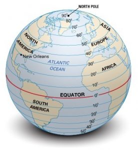
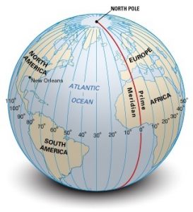
Together, longitude and latitude form a coordinate system to quickly and easily identify a position on Earth. The goal of this activity is to familiarize students with using longitude and latitude to locate places on Earth.
Suggested Videos:
- Latitude and Longitude
- How the International Date Line Works
- Understanding Time Zones
- Animation Explaining the International Date Line
- As you watch these videos, think about the following:Q: What is the shape of the earth?
As you watch the videos, think about the following questions: What is the purpose of latitude and longitude?
How do we describe location on earth?
How do these imaginary lines relate to keeping time on Earth?
Where does a new day begin?
What is the international date line?
Activity:
- Using a map above, answer the following questions:
- Which continent is located at 40° N, 100° W?
- Which continent is located at 30° N, 100° E?
- Which continent is located at 20° S, 50° W?
- Which country is located at +60.0°, +120.0°?
- Which ocean is located at -50.0°, -140.0°?
Activity 3 – Predicting shadow length from solar angles

In this activity, students will demonstrate their understanding of longitude and latitude by finding geographical coordinates for specified places and drawing their location on a diagram indicating the appropriate coordinates.
- Measure an outside object, such as a fence pole, fire hydrant, slide, or stick. If needed, you can construct an item or use one from your classroom.
- Using the solar angles from their worksheet calculations, have students predict the shadow of that outside object.
Hint: make sure you perform the measurement at the same time and date as your calculations.
Troubleshooting tips:
- Note that longitude and latitude can be expressed as fractional degrees or in terms of “minutes” and “seconds.” For simplicity, stick with fractional degrees as this is the easiest format to understand when converting “minutes” and “seconds” to fractional degrees.
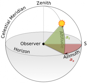
- So students can prepare for this activity, assign it about a week after doing the worksheet on calculating solar time, solar altitude, and solar azimuth. For added problems, watch the following video on finding longitude and latitude:
Additional Resources
Books
Longitude: The True Story of a Lone Genius Who Solved the Greatest Scientific Problem of His Time, by Dava Sobel. An illustrated version supplements the 1995 text with 178 images depicting the how a clockmaker named John Harrison invented a truly reliable chronometer and gave rise to Britain’s dominance of the seas while changing the world’s concept of time.
Websites
Stellarium A free, open-source planetarium for your computer similar to ones being used in planetarium projectors. It shows a realistic sky in 3D, just like what you see with the naked eye, binoculars, or a telescope. Just set your coordinates and go.
Activities
Angular Size and Similar Triangles and Last Total Eclipse Ever! from NASA Education’s SpaceMath program explores angular measurement through learning about parallax and how astronomers use this geometric effect to determine the distance to Venus during a Transit of Venus.
Build a Sun Track Model. Stanford University and NASA team up in this activity using paper plates and pipe cleaners to build a model of the sun’s year-long journey across Earth as the season’s change.
Measuring Shadows and Determining Sizes of Angles. NASA Education’s outdoor activity has students use yardsticks and rocks on string to measure the angle of the sun at 10 minute intervals, then calculate tangents and infer topography, as space scientists might do to study Mars. [YouTube 4:05]
Sunstruck! An Integrated Solar Education Experience NASA teamed up with the Michigan Science Center on this program primarily for middle school students and the general public on the sun and its effect on Earth and the solar system. Includes an interactive heliostat exhibit, Dassault Systemes Planetarium program.
Total Solar Eclipse! NASA Education’s comprehensive guide to the August 21, 2017 solar eclipse that will cross the United States. Take photos, measure the temperature at totality in your back yard, and other citizen science projects along with how to safely view this rare phenomenon.
Your World is Tilted LearnNC, a project of the University of North Carolina, Chapel Hill’s School of Education, created this visual/demonstration of why days are longer in summer and shorter in winter in the Northern Hemisphere, the opposite in the Southern Hemisphere.
Videos
Earth Sun Geometry. Creighton University associate professor of atmospheric science John M. Schrage’s video presentation for his 2012 course on computing the sun’s angles and other calculations. [YouTube 16:09] See also Schrage’s Computing Sun Angles [YouTube 16:29].
Measuring Shadows and Determining Sizes of Angles. NASA Education’s outdoor activity has students use yardsticks and rocks on string to measure the angle of the sun at 10 minute intervals, then calculate tangents and infer topography, as space scientists might do to study Mars. [YouTube 4:05]
Physical Science 9.2a -The Earth Moon Sun and Physical Science 9.2b -Rotation and Revolution
Spaceship Earth – An animated documentary of how Earth works.
Other
NOVA: The Search for Longitude James I. Sammons, a teacher at Jamestown School in Rhode Island, contributed this lesson on the history of developing a way to calculate longitude for PBS Education.
Acknowledgements
This lesson on solar geometry is possible due to the generous donations of Penn State lighting collaborative ProjectCANDLE and the National Science Foundation-funded STEM initiative, CarbonEARTH.
- Project CANDLE is a partnership to Create an Alliance to Nurture Design in Lighting Education. It is a collaboration between Pennsylvania State University, the International Association of Lighting Designers (IALD) Education Trust, and lighting industry partners.
- CarbonEARTH (Educators And Researchers Together for Humanity) fellowship program is part of a 5-year National Science Foundation (NSF) GK-12 grant that pairs teams of Penn State science, technology, engineering, and mathematics (STEM) graduate students with elementary and middle school science teachers from Pennsylvania’s Philipsburg and Harrisburg school districts.
Filed under: Class Activities, Grades 6-8, Lesson Plans, Special Features
Tags: angle, calendar, Class Activities, day, earth sciences, eclipse, Environmental Engineering, Environmental science, Geometry, globe, Grades 6-8, latitude, Lesson Plans, light engineering, longitude, map, Mathematics, NASA, Project CANDLE, season, Solar Geometry, sun, Tony Esposito Jr.


