


Save Our Shore!
Coastal engineering activity courtesy of the University of Hawai’i at Manoa series: Exploring Our Earth: Teaching Science as Inquiry. Video and additional resources curated by eGFI.
High school teachers might wish to use NOAA’s Who Moved the Beach coastal management lesson.
Summary
In this activity, students in grades 3 to 8 learn about coastal erosion and the role of engineers in protecting shorelines by applying the engineering design process to devise ways to mitigate erosion that take public concerns into account – and use both structures and policies.
Grade level: 3 – 8
Time: 50 – 120 minutes
Learning Objectives
After doing this activity students should be able to:
- Understand the causes of beach erosion
- Apply the engineering design process
- Develop solutions that address public needs and concerns
- Evaluate the strengths and weaknesses of different designs
- Understand constraints as a crucial element in problem solving
- Understand the role of policy in developing solutions
Standards
Next Generation Science Standards
- Planning and carrying out investigations
- Developing and using models
- Cross-cutting concepts
- Disciplinary Core Ideas: Earth Systems, including human impact and Developing Solutions, including engineering design.
Materials
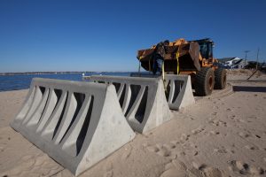
FEMA installs prism barriers at Ocean Gate, NJ, to prevent erosion after Hurricane Sandy in 2012.
- Flat wave tank or large flat plastic bin
- Water
- Wind generating source (e.g., fan) or paddle or other object to displace water
- Table with Examples of Anti-Erosion Structures [PDF HERE]
- Sand
- Toothpicks
- Assortment of small rocks
- Small building blocks or other waterproof objects to represent houses
- Rosemary sprigs or other objects to represent vegetation
- Ruler
- Towels
- Protractor (optional)
- Metronome or other sound recording device (optional)
- Camera (optional)
- Computer program to analyze beach area on pictures (optional)
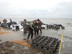
Photo: Rebuilding after Hurricane Sandy, U.S. Fish and Wildlife Service partners with the Nature Conservancy to erect “sand castle” barriers on Gandy’s Beach to protect Delaware Bay oyster beds from coastal erosion. Credit: Adrianna Zito-Livingston/The Nature Conservancy
Procedure
Safety Note: If using an electrical device to generate waves, keep the device far away from the water. Promptly clean up splashes to prevent slipping. Consider doing the wave tank part of this activity outside if the weather permits.
A. The Scenario
Your group is a coastal management engineering firm. You are competing with the other groups in your class for a contract from a town called Seaside. Over the past few years, Seaside’s sandy beaches have been eroding. You must develop a plan to help the town manage its erosion problem. Your plan must include modifying the beach in some way to address immediate erosion concerns. Your plan must also include at least two policies that do not physically alter the shoreline, but instead regulate human behavior.
Each of the major stakeholders (groups of people with an interest in the issue of coastal erosion) in town will vote on your idea. In order to win the contract, you must balance their competing interests. Your teacher may also give you additional criteria to consider, such as a specific budget or other feasibility constraints.
| Business Owners: Seaside depends on its beaches to bring tourists who will spend money in Seaside. Business owners are concerned that erosion is keeping tourists away. The business owners want a management plan that will solve the erosion problem as soon as possible and cost as little as possible. |
| Recreational Users: Surfers and swimmers in town are concerned about the erosion problem and whether it will get worse as a result of global warming and sea level rise. They want a management plan that is aesthetically pleasing (looks nice, but does not have to be all-natural) and does not alter the water dynamics too much (so they can keep doing their normal activities like surfing and snorkeling). |
| Environmentalists: An environmental group wants to protect the habitat of an endangered intertidal crab that lives on one area of the beach. They would prefer that hard structures not be built on the beach. They want a management plan that preserves the crab habitat, maintains natural features, and prioritizes the long-term health of the beach. |
| Property Owners: There are some houses near the beach. As the beach is eroding, these houses are at risk. The owners who live in these houses want to build a seawall or other hard structure to save their properties and will pay for half of the cost themselves. They want a management plan that will solve the erosion problem immediately. |
Have a class discussion to come up with the criteria for determining the effectiveness of your engineering plan on controlling beach erosion, a concern of all of the stakeholders. The following are some erosion criteria to consider. Come to a class consensus on which of these criteria you will measure and how you will measure it. You may come up with criteria that are not on this list.
- The height of the coastline
- The width of the coastline
- The overall shape of the coastline
- The amount of sand pulled out to sea
- How far up the shore the waves reach
B. Set up standardized wave tanks
You will use a wave tank to develop and refine your coastal management strategies.
- (Optional) Wash the sand and rocks before the activity to remove fine particles that will make the water in your tank muddy.
- Fill the tank with water to about one-third full. The height of the water should be the same among all groups.
- Practice generating waves with a wind source or by displacing water using a paddle or other object. All groups should generate waves using the same method, they should have similar amplitudes and frequencies. Consider using a metronome to standardize wave frequency.
- Create a beach by carefully pouring sand into one end of the tank, so that a portion of the sand extends above the waterline. Standardize as many variables as possible, you may think of more than the following factors:
- The total amount of sand
- The height of the beach
- The width of the beach
- The location of the endangered crab habitat (mark with toothpicks)
- The number and location of the houses
- (Optional) Collect baseline data as a class in one of the tanks. This represents what will occur if nothing were done to the beach.
- Mark the shoreline with toothpicks.
- Sketch profile and top views of your coastline before generating waves.
- Measure things that correspond to your class beach erosion criteria (e.g., beach width)
- (Optional) Take “before” pictures of the wave tank and shoreline.
- Generate waves for 5 minutes. Try to keep the waves consistent in amplitude and frequency.
- Observe the wave patterns that are created. Make sketches of the wave patterns.
- At the end of the trial, draw profile and top views of the coastline. To observe changes in the shoreline, compare the location of the current waterline with the location of the toothpicks, which represents the location of the waterline at the beginning of the investigation.
- Measure things that correspond to your class beach erosion criteria (e.g., beach width)
- (Optional) Take “after” pictures of the wave tank and shoreline.
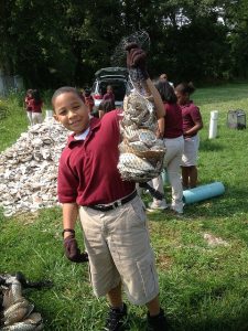
Photo: Bridgeton, N.J., student displays a full shell bag, one of 15,000 to be used to protect the Gandy’s Bay oyster beds. The bags will be placed offshore to create a 4,000 “living breakwater.” See U.S. Fish & Wildlife Service article HERE.
C. Develop Your Management Plan—Shoreline Modifications
- Choose a name for your coastal management engineering firm.
- In your group, discuss your ideas for managing Seaside’s erosion problems. You might consider multiple approaches in your plan to alter the shoreline. The following are some things you might consider:
- Building hard structures (some examples are in Table 5.12)
- b. Stabilizing the shore with “soft” non-structural techniques, for example, importing or shifting sand or planting vegetation
- Test your structural ideas in the wave tank following Part B Step 5. During this time while you are developing and improving solutions, you may choose not to follow all of the steps, or you may generate waves for less time than suggested.
- Collect final “before” and “after” data on your design plan by following all of the steps in Part B Step 5. The data you collect will be used in your presentation to stakeholders.
- When cleaning up, dry out the sand before storing it by spreading it out in a pan or on plastic tarps in the sun.
- Analyze and interpret your data.
- Compare your “before” and “after” data. How did the shoreline change? How much did it change?
- (Optional) Compare your “after” date to the “baseline” data collected in Part B. How did your plan compare to “doing nothing”?
- (Optional) If you took “before” and “after” pictures, analyze them to determine the difference in beach area (e.g., in cm2).
D. Develop Your Management Plan—Policies
- Based on your wave tank results, and applying what you know about human behavior, suggest two policies for Seaside to consider as part of your management plan.
- If your wave tank results show a weakness in your design, policies may be added to prevent that weakness from becoming a problem (e.g., not building in a certain area).
- Policies can also be used to help enforce an aspect of your plan that might not be desirable to all of the stakeholders. However, remember that if your policies are unrealistic, none of the stakeholders will vote for your idea.
- The following are some policy ideas—be creative in coming up with your own!
- Relocating structures to areas further away from shore (managed retreat)
- Buying-back houses that are too close to the shoreline, destroying the houses and relocating the owners
- Setting construction set-back limits
- Placing signs on dunes to stop people from walking on them
E. Communicate your management plan
- Plan with your group how you will present your design solution, including your policy suggestions, to the stakeholders.
- You will be given a set amount of time (e.g., 5 min) to present your design.
- Decide how you will present your idea: wave tank demonstration, computer presentation, flyers, etc.
- You may want to share your before and after pictures and make charts with your data.
- Communicate your management plan to the Seaside stakeholders. Your teacher might represent all of the stakeholders, other adults or students might role-play a representative from each stakeholder group, or everyone in the class might each be assigned to a stakeholder group.
- (Optional) Prepare a written engineering design proposal. Use this opportunity to refine your ideas, taking into account any feedback from the stakeholders.
- Evaluate your proposed solution compared to other groups.
- How were different group proposals similar? How were they unique?
- Which proposal do you think met each of the four stakeholder’s needs best? Why?
- What policies did people suggest that went over particularly well? What policies did people suggest that were met with resistance? Why?
- What were the limitations of your proposal?
- How well do you think the wave tank modeled engineering designs in the real world? How could the model be improved?
- Were there things you could have changed to improve your design?
- How do seawalls, breakwaters, jetties, and other hard structures affect sand transport? What are the negative aspects of these structural stabilization strategies?
- How do natural ways of stabilizing the shoreline, such as restoring native plant habitats, protect the coast?
- List at least five reasons why it is important for people to protect beach areas from erosion.
- Many people want to live as close to the water as possible. Based on your studies, what guidelines would you give a prospective homebuilder who wants to purchase or build near to the water?
- The accretion, or build-up of sand where it does not normally occur, can be as detrimental as sand erosion. List at least five reasons why it may be important to people to protect against sand accumulation.
Additional resources
Research Reports
Protecting the Health and Well-being of Communities in a Changing Climate Proceedings of a 2017 National Science Foundation workshop (brief report).
Websites:
Coastal Erosion. National Oceanographic and Atmospheric Administration’s “climate resilience toolkit” includes effective strategies for dealing with coastal erosion and case studies.
Coastal Erosion Control Design. NewYork State’s Department of Environmental Conservation site.
Dune Grass Planting. NOAA video and article on effort to stabilize the beach at the Oceana Naval Air Station by planting panic grass.
Protecting our Coastline. Blog post primer on sea walls, jetties, groins, beach fences, and other methods of protecting shorelines by a Massachusetts civil engineer.
Shells and Students. U.S. Fish and Wildlife Service article on Project PORTS – Promoting Oyster Restoration through Schools – and building living reefs off of coastal New Jersey using bags filled with oyster shells.
Shoreline Engineering. Primer on “stabilizing the unstable” with jetties, groins, and other engineered solution.
U.S. Climate Resilience Toolkit. NOAA’s site includes case studies, such as restoring dunes in New Jersey after Hurricane Sandy to protect the shoreline, a guide to risk assessment, and ideas for taking action.
Videos:
Another Day of Fighting Beach Erosion on Australia’s Gold Coast. Popular seaside resort spends $20,000 a day on sandbags and other emergency measures to protect property. [YouTube 2:19]
Beach Erosion. Time-lapse video from Florida Institute of Technology’s wave tank showing the effects of waves and wind on sand. [YouTube 1:41]
Drone video of eroding seaside cliffs threatening Pacifica, Calif. [YouTube 6:02]
Erosion at the Beach. FunScienceDemos uses tub of sand and water to simulate erosion. [YouTube 3:32]
House on Cliff’s Edge Falling into Ocean! 2010 CNN report on Pacifica, Calif., home teetering on edge of rapidly eroding cliff. [YouTube 1:38] And the view in 2016.
King Tide Swamps La Jolla (Calif.) Aerial video of Nov. 26, 2015 tide that inundated La Jolla, California. [YouTube 1:12]
Methods Used to Slow Down Coastal Erosion. Short 2011 tutorial on engineered and sustainable ways currently used to ease coastal erosion. [YouTube 1:41]
What if your home was slipping into the ocean? National Geographic documentary about a community on North Carolina’s Outer Banks that is fighting erosion. [YouTube 4:49]
What is coastal Erosion? British Environment Agency explains the four major types of erosion. [YouTube 4:11]
Filed under: Class Activities, Grades 6-8, Grades 6-8, Grades 6-8, Grades K-5, Grades K-5, Grades K-5, Lesson Plans
Tags: beach, Civil Engineering, Class Activities, coastal engineering, Earth Science, Engineering Design Process, Environmental Engineering, erosion, Grades 6-8, Grades K-5, Lesson Plan, Marine Science, sand