


Who Moved the Beach?
Activity adapted from the National Oceanic and Atmospheric Administration’s coastal management lesson plans. Click HERE for PDF and HERE for html. (Note: Many links cited in original lesson are broken; the following activity restores some and replaces others.)
Summary
High school students working in groups of three to four learn about the primary causes and impacts of coastal erosion, and use elevation data to construct profiles of three beaches, make inferences about the erosion process, and discuss how humans should respond.
Grade Level: 8 to 12
Time: 45 minutes (one class period), plus time for student research
Learning Objectives
After doing this activity, students should be able to:
- Identify coastal erosion as a natural process and explain how human activity can increase the risks associated with coastal erosion.
- Identify options for reducing risks caused by coastal erosion and the advantages and problems associated with each.
- Analyze and interpret beach elevation data and make inferences from these data about the relative vulnerability of different beaches to coastal erosion.
Learning Standards
National Science Education Standards
Content Standard A: Science as Inquiry
- Abilities necessary to do scientific inquiry; Understandings about scientific inquiry
Content Standard B: Physical Science
- Motions and forces; Interactions of energy and matter
Content Standard D: Earth and Space Science
- Energy in the earth system; Geochemical cycles
Content Standard E: Science and Technology
- Abilities of technological design
Content Standard F: Science in Personal and Social Perspectives
- Natural resources; Environmental quality; Natural and human-induced hazards; Science and technology
Next Generation Science Standards
Earth Systems
- Make observations and/or measurements to provide evidence of the effects of weathering or the effects of erosion by water. (Elementary)
- Collect data to provide evidence for how the motions and complex interactions of air masses results in changes in weather conditions. (Middle)
K-12 Ocean Literacy framework, scope and sequence guide
Engineering Motivation/Background
Almost half of the people in the United States live near the coast. As the coastal population continues to grow, more people and property will be exposed to hazards caused by severe storms, floods, shoreline erosion, and other natural hazards. Homes and businesses are often built in low-lying areas and barrier islands that are particularly vulnerable to storm damage. The potentially disastrous consequences of this trend became obvious during the summer of 2004, when residents of Florida were battered by four major hurricanes within six weeks, resulting in billions of dollars worth of damage. Much of the price is eventually borne by American taxpayers through federal government funds for disaster relief and reconstruction.
While erosion and land subsidence (land sinking below sea level) are less spectacular than strong storms, they are just as important in economic terms. Erosion alone is estimated to cause billions of dollars of damage every year along U.S. coasts. Subsidence around New Orleans has necessitated large expenditures for pumping and dike maintenance. Subsidence in Texas, Florida, and California threatens high-value land uses and causes damages that cost millions to repair. Attempts to protect against coastal hazards can cause additional problems. Sea walls intended to protect against storm waves can actually accelerate beach erosion and reduce the capacity of beaches to absorb storm energy. As a result, buildings adjacent to the beaches are exposed to the full force of wind and waves. Human activities such as diking and drainage of land around New Orleans, ground water removal in Texas and Florida, and extraction of oil and gas in California have accelerated subsidence in these areas. (See, for example, the U.S. Geological Service’s page on subsidence.)
Experience has shown that prevention is the best approach to deal with these problems. It costs much less to prevent construction in areas unsuitable for development than to provide funds for emergency response, cleanup, and reconstruction. NOAA’s Office of Ocean and Coastal Resource Management works in partnership with state governments to minimize the impact of coastal hazards by:
- Identifying areas that are most likely to be severely affected by these hazards;
- Developing warning systems and response plans to minimize human exposure to hazardous events;
- Establishing appropriate building codes; and
- Restoring the natural protective functions of beaches and dunes.
See NOAA’s Digital Coast site for more information. For data sets, see NOAA’s Digital Coast Data Sets and Shoreline Data Explorer.
From 1996 to 2000, the National Ocean Service, NASA, and the U.S. Geological Survey partnered in an Airborne LIDAR Assessment of Coastal Erosion (known as the ALACE project). LIDAR stands for light detecting and ranging, and is part of NASA’s Airborne Topographic Mapper (ATM). The ATM system uses a laser altimeter installed in an aircraft. As the aircraft flies along the coast, the altimeter scans the earth’s surface in a path several hundred meters wide, and acquires an estimate of ground elevation every few square meters. The ALACE project collected topographic data (elevations of dunes and beaches) along U.S. coasts. These data have been used to create maps that show the relative vulnerability to coastal erosion. These maps can be used to quickly locate areas that may be severely impacted by coastal storms, to help plans for emergency response as well as environmentally appropriate development.
Maine Geological Survey’s report, Using LIDAR to Monitor Beach Changes, provides a clear explanation, with images and graphs, of how this technology was used from 2004 to 2006 to map changes in the state’s shoreline.
Also see NOAA’s Coastal Topgraphic Lidar data sets, LIDAR 101 (includes data sets), and introduction to LIDAR.
Materials
- Computers with Internet access
- Copies of “Coastal Erosion Subject Review Worksheet,” (pages 10 – 12 of PDF or click HERE for html and HERE for word doc with updated links); one copy for each student or student group (Note: some websites no longer exist.)
- Graph paper or computers with spreadsheet and graphing software
Procedure
Note: If you want to introduce this lesson by showing images of severe coastal erosion, such as that caused by hurricanes, visit the NOAA photo library at http://www.photolib.noaa.gov/
1. Tell students that their assignment is to learn about coastal erosion processes by completing the “Coastal Erosion Subject Review Worksheet.” [docx] If students do not have access to the Internet, download copies of materials cited at the beginning of the worksheet and make one copy of each article available to each student or student group.
2. Review answers for the worksheet. [See pages 4-6 of PDF for correct answers.]
3. Review the idea of the ALACE project and LIDAR mapping, which students may have encountered while researching answers for the worksheet. Ask students what sorts of beach profiles might be most resistant to wave erosion.
Either follow the BRIDGES data exercise, using measurements for Ocean City, Md., to plot the change in the beach’s elevation and profile over time on graph paper or a spreadsheet. Click HERE for a beach profile graphing exercise using this beach.
Or use beach profile data from a source such as:
- The state of Maine’s annual beach reports or Shore Stewards online data collaborative, which offers downloadable data from 15 beaches. There’s also an online beach profile data viewing site.
- Washington and Oregon’s beach morphology research program has profile survey data for four beaches.
- Florida state has beach survey profiles.
- Britain’s Slapton Ley has downloadable annual beach profile data surveys (Excel)
- The University of Hawaii’s sea-level data to compare how beaches are shifting in different U.S. coastal regions. Oahu also posts data on its beaches.
 Live near a beach? Take your own coastal profile measurements, like this group of students measuring the shoreline at Cape Hatteras National Park. See the University of Maine’s helpful how-to guide for volunteer beach monitors, or Analyzing the Dynamics of a Beach, an activity from the University of Florida.
Click HERE for Texas A&M’s primer on beach profile surveys and interpreting trend-data graphs.
4. Lead a discussion of students’ beach profiles. Ask students to infer which beaches might be the most vulnerable to wave erosion. Do the beaches have conspicuous dunes, for example? Ask what might account for the differences in the profiles for the same stretch of Ocean City, Md., beach. Students should recognize that a beach may have been exposed to winter storms that increase erosion and move sand offshore, but that by fall this sand could have been returned by the gentler waves typical of summer months. Be sure students realize that the offshore areas that receive eroded sand are obviously involved in these processes, and in fact are part of the total beach profile.
Discuss the three options for responding to erosion threats listed in the last question on the worksheet. Students should realize that while leaving may be the least expensive option, this is often impractical where development has already taken place. Renourishment, however, is seldom a permanent solution. (See Assessing the Environmental Impacts of Beach Nourishment by University of North Carolina, Chapel Hill, researchers, or NOAA’s 2000 report on state beach nourishment programs.) Similarly, various construction options can make property more resistant to erosion, but structures such as sea walls, jetties, and bulkheads often increase erosion. (See armoring example at Wells Beach, Maine.)
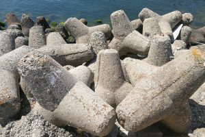
Closeup of concrete tetrapod to prevent coastal erosion and provide barrier protection against strong waves
Reports and articles needed to complete worksheet:
“Evaluation of Erosion Hazards,” (Summary) April 2000 report prepared for the Federal Emergency Management Agency by the H. John Heinz III Center for Science, Economics, and the Environment. Read full report.
NOAA’s Coastal Hazards Assessment.
National Assessment of Storm-induced Coastal Change Hazards.
Beaches on the Brink. 2000 CNN report.
Activity Extensions
Build and use a stream table to simulate erosion and other processes involving sediment transport by water. (Source: Missouri Stream Team Information)
Resources
Research Reports
Protecting the Health and Well-being of Communities in a Changing Climate Proceedings of a 2017 National Science Foundation workshop (brief report).
For Educators: Labs, Lessons & Other Hands-on Coastal Geography and Environmental Engineering Science sites
The BRIDGE,” an ocean of free, teacher approved marine science education resources” from the College of William and Mary’s Virginia Institute of Marine Science, includes a “immerging properties” seal level investigation using data, “where’s the beach” Data activity that uses data to analyze erosion and a coastal geology lab from Oregon State University.
Live near a beach? Take your own beach profile measurements. (See the University of Maine’s helpful how-to guide for volunteer beach monitors.) Or use the University of Hawaii’s sea-level data to compare how beaches are shifting in different U.S. coastal regions.
Graphing the Beach Profile. How-to guide from the education program of the New Jersey Sea Grant Consortium includes how to count bird and human tracks.
Websites:
Coastal Erosion. National Oceanographic and Atmospheric Administration’s “climate resilience toolkit” includes effective strategies for dealing with coastal erosion and case studies.
Coastal Erosion Control Design. NewYork State’s Department of Environmental Conservation site.
Coastal Hazards. NOAA’s website include podcasts, interactive sea-rise viewer, facts about coastal vulnerabilities, and infographic about coastal resilience.
Coastal Management. NOAA’s Office for Coastal Management includes state-by-state information on topics from coastal zone management to coral restoration, and fast facts on ocean debris, ports, and economics.
College of William & Mary’s Virginia Institute for Marine Science includes GIS data, decision trees for defending coastlines, and a K-12 education site.
Dune Grass Planting. NOAA video and article on effort to stabilize the beach at the Oceana Naval Air Station by planting panic grass.
Protecting our Coastline. Blog post primer on sea walls, jetties, groins, beach fences, and other methods of protecting shorelines by a Massachusetts civil engineer.
Shells and Students. U.S. Fish and Wildlife Service article on Project PORTS – Promoting Oyster Restoration through Schools – and building living reefs off of coastal New Jersey using bags filled with oyster shells.
Shoreline Engineering. Primer on “stabilizing the unstable” with jetties, groins, and other engineered solution.
Taking the Pulse of a Beach. Maine Geological Survey’s July 2013 uses the U.S. Geological Service’s Digital Shoreline Analysis System to calculate the shoreline’s changes over time.
U.S. Climate Resilience Toolkit. NOAA’s site includes case studies, such as restoring dunes in New Jersey after Hurricane Sandy to protect the shoreline, a guide to risk assessment, and ideas for taking action.
Dune Migration and Shoreline Protection from Climate.gov on Vimeo.
What causes beach erosion? Scientific American answers a reader’s question about East Coast beach erosion.
Videos:
Another Day of Fighting Beach Erosion on Australia’s Gold Coast. Popular seaside resort spends $20,000 a day on sandbags and other emergency measures to protect property. [YouTube 2:19]
Beach Erosion. Time-lapse video from Florida Institute of Technology’s wave tank showing the effects of waves and wind on sand. [YouTube 1:41]
Drone video of eroding seaside cliffs threatening Pacifica, Calif. [YouTube 6:02]
Erosion at the Beach. FunScienceDemos uses tub of sand and water to simulate erosion. [YouTube 3:32]
House on Cliff’s Edge Falling into Ocean! 2010 CNN report on Pacifica, Calif., home teetering on edge of rapidly eroding cliff. [YouTube 1:38] And the view in 2016.
King Tide Swamps La Jolla (Calif.) Aerial video of Nov. 26, 2015 tide that inundated La Jolla, California. [YouTube 1:12]
Methods Used to Slow Down Coastal Erosion. Short 2011 tutorial on engineered and sustainable ways currently used to ease coastal erosion. [YouTube 1:41]
What if your home was slipping into the ocean? National Geographic documentary about a community on North Carolina’s Outer Banks that is fighting erosion. [YouTube 4:49]
What is coastal Erosion? British Environment Agency explains the four major types of erosion. [YouTube 4:11]
Activity posted May 2017.
Filed under: Class Activities, Grades 9-12, Grades 9-12, Grades 9-12, Lesson Plans
Tags: beach, Civil Engineering, Class Activities, coastal erosion, coastal management, data analysis, Earth Science, Environmental Engineering, erosion, Grades 9-12, jetties, Lesson Plan, NOAA, USGS