


Where’s Your Teacher?

Activity courtesy of Teachengineering.org. Click HERE to see other activities in the Plot Your Course unit on navigation, including lessons in making your own compass, reading topographical maps, and figuring the width of rivers.
Summary
In this activity, students in grades 7 to 9 will learn how to take a bearing with a compass and find an object in their classroom.
Grade: Level: 7-9
Time: 30 minutes
Engineering Connection
Understanding bearing is essential to engineers who design radar tracking and surveillance systems used for everything from scientific study to defense. Some radar systems measure distances and map geographical areas, others help to navigate at sea. Aircraft radar warns of obstacles, provides altitude readings and helps land planes in fog or by remote control. Radar is used for daily weather forecasting, and monitoring severe weather such as tornados and hurricanes. Radar systems are used to study the planets and the solar system, including tracking Earth-orbiting human-made satellites, space debris, meteors and other objects in outer space.
Standards
Common Core State Mathematics Standards
Make formal geometric constructions with a variety of tools and methods (compass and straightedge, string, reflective devices, paper folding, dynamic geometric software, etc.). [Grade 9]
International Technology and Engineering Educators Association
F. Knowledge gained from other fields of study has a direct effect on the development of technological products and systems. [Grades 6 – 8]
Learning Objectives
- Understand the basics of how to use a compass, including taking a bearing and finding the direction of bearing
- Measure degrees
- Understand how navigation technology is used in engineering
Materials
- 1 Group Handout worksheet [pdf]
- 2 Individual handouts [pdf]
- 1 or 2 compasses (depending on how you want to organize the activities)
Motivation
If you are unable to use landmark navigation (identifying known landmarks to determine your location) for getting around, how could you navigate the wilderness or an unfamiliar city? (Possible answers: Look at a map, use a compass, use a map and a compass together.) Why are you not able to use landmark navigation in unknown areas like you do in your own familiar surroundings? (Possible answer: Because you do not know the relative location of landmarks if you have never been there before.) What if you do not know how to use a compass, then what? Learning how to use a compass requires skills, but with a little practice, even new users can get the hang of it and find directions using a compass. The concepts of taking a bearing and using a compass to measure a bearing are investigated in this activity.
Procedure
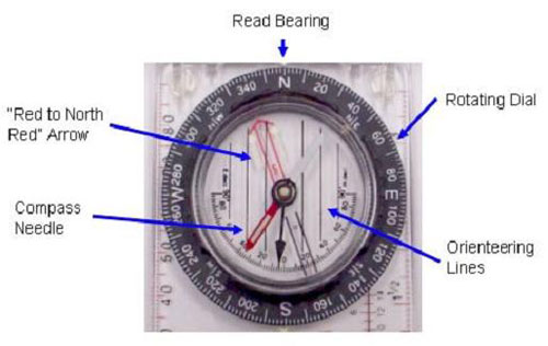
An Introduction to the Orienteering Compass
 Copyright © M. Lippis, University of Colorado, Boulder, 2003.
- “Red to North Red” Arrow – this arrow moves with the rotating dial to align with the compass needle. Notice the luminous lines around the top: these help to see in the dark.
- Compass Needle – this needle points in the direction of the magnetic field. The red end points to magnetic north. Notice the luminous line in the middle: this helps to see the needle in the dark.
- Read Bearing – after aligning the compass needle within the “red to north red” arrow, the bearing is read here.
- Rotating Dial – rotating this dial allows you to align the red-to-north-red arrow with the compass needle. This dial has the direction on it.
- Orienteering Lines – these lines are used with topographical maps. Topographical maps have grids on them that allow you to align the map and the compass.
Taking a Bearing Using a Compass
- Face some object, like a mountain or a tree, that you want to which you want to know the direction.
- Open up your compass (if it opens), and put it against your stomach, or belt, facing straight ahead of you.
- Rotate the rotating dial until the red end of the compass needle lies between the red arrow facing north.
- Read the bearing from the compass. Looking at the compass, this should be the number on the dial that is facing the front of the compass. Usually the compass has a little tick mark or might even say “READ BEARING.”
Following a Bearing Using a Compass
- Rotate the rotating dial until the red end of the compass needle lies between the “red to north red” arrow.
- Now, walk in the direction that you need to go (in our case, west), being sure to always keep your compass needle between the “red to north red” arrow (i.e., if you need to go west back to camp, look at the compass to see what direction west is — then just walk in that direction).
- It is often easy to start veering off from the direction you really want to head. An easy solution for this is to place the compass against your stomach or belt so that you can always look down and make sure you are heading in the right direction.
Before the Activity
- Read through all the steps in the “With the Students” section.
- Print the Individual Handouts and Group Handouts.
With the Students
- Break the students into groups of two or more (the smaller the group, the better).
- Give each group a Group Handout and one (or more, if available) compass.
- Tell students that they have a couple minutes to answer the first question. They should determine which direction the needle is pointing on their compass.
- Now, they have 5 minutes to take a bearing. When they are done, ask them to verify what they have just done. (Answer: they took a bearing). What is a bearing? (Answer: the direction of some object relative to them.)
- Students should next spend 5 minutes finding the bearing of their teacher.
- Have the students compare their answers with other groups. If they have answers different from other groups, ask them why. (Answer: Because the bearing of an object is dependent on the location from which they took the bearing.)
- Give each student the Individual Handout and complete the exercise with the students.
- Tell them to pick any object in the classroom and write down the first letter of that object on their handout.
- Have them take the bearing of the selected object and write it down on their handout.
- Once done, they should pick a partner.
- Have them exchange handouts and desks/seats with their partner.
- Now that they have their partner’s handout and they are sitting at their partner’s desk, ask them to find the object their partner picked.
- When done, they should discuss with their partners whether or not they correctly guessed each other’s object. Students should not reveal their object to their partner if they did not correctly guess — they should try again.
- Ask students why they had to sit in each other’s seats? (Answer: Because the bearing of an object is dependent on where the bearing was taken from. Since their partner took the bearing at their seats, they had to use that same seat to get the correct bearing.)
Troubleshooting Tips
Pre-Activity Assessment
- Who has used a compass before? What is a compass for? (Possible answers: To find an unknown location, to measure an object’s location.)
- How does it work? (Answer: A compass works by using the Earth’s magnetic north pole and directional pulls to determine north, south, east and west directions.)
Activity Embedded Assessment
Post-Activity Assessment
- 8-10 students at a time should line up and form a human compass in the front of the room. Have the other students shout out a direction for the compass to “point”; students should discuss why or why not it was easy to determine directions.
- For 6th grade, have two students, instead of one, determine an object and its bearing for Part II of “With the Students” in the Procedure section. Have them switch with another group of two students.
- For 7th and 8th grade, do the activity as is.
Contributors: Matt Lippis, Penny Axelrad, Malinda Schaefer Zarske, Janet Yowell
Copyright © 2004 by Regents of the University of Colorado. Supporting program: Integrated Teaching and Learning Program, College of Engineering, University of Colorado Boulder
The contents of this digital library curriculum were developed under a grant from the Satellite Division of the Institute of Navigation (www.ion.org) and National Science Foundation GK-12 grant no. 0338326.
Filed under: Class Activities, Grades 6-8, Grades 6-8, Lesson Plans
Tags: bearing, Class Activities, compass, directions, Engineering, estimation, GPS, Grades 6-8, Grades K-5, maps, Mathematics, navigation, wilderness